The ability to operate unoccupied aircraft systems (UAS), or drones, and analyze the data they collect is becoming an essential skill for professionals in GIS, environmental science, and land management. It represents a major shift in how we gather, process, and interpret geospatial information.
UVM’s online Intro to UAS and Geospatial Applications course is designed to provide this exact expertise. As one of eight specialized courses in the Professional GIS & Data Communication Certificate, it offers a direct path to mastering this transformative technology.
We sat down with the course instructors —Dr. Paige Brochu, Adam Zylka, Lauren Cresanti, and Kelly Schulze from UVM’s Spatial Analysis Laboratory— to get an inside look at the curriculum, the learning experience, and the career outcomes for students.
“We’re empowering learners to move from raw drone imagery to defensible, decision-ready products—so they can answer environmental questions with confidence and speed.”
— Dr. Paige Brochu, Director, UVM Spatial Analysis Laboratory
This course instructor interview provides a detailed course overview and answers common UAS and drone mapping training questions:
- Why was this UAS and Geospatial Applications course created?
- Who is this course for?
- How does this course get students ready for real-world drone jobs?
- What’s special about this course compared to other drone programs?
- What software and tech will I use in this course?
- What kinds of projects will I work on?
- How are hands-on skills like flight planning taught online?
- What’s the most valuable skill I’ll learn from this course?
- What jobs can I get after completing this UAS training?
- What’s a common misunderstanding people have about drone mapping?
- How does this course relate to the FAA Part 107 certification?
Why was this UAS and Geospatial Applications course created?
This course was developed in response to the growing need for GIS professionals who can leverage drone technology for complex environmental challenges. The UVM team recognized a gap in practical training that bridges traditional GIS skills with real-world drone operations and data analysis.
“GIS is evolving rapidly, and professionals need the ability to integrate drone-based data into their work. We created this course to give learners applied experience with the latest UAS technology and analysis techniques. Our aim is to empower students to address pressing environmental and geospatial issues in their careers.”
— Dr. Paige Brochu, Director, UVM Spatial Analysis Laboratory
Who is this course for?
The course is designed for a wide range of individuals. This includes students interested in learning more about this technology, current GIS professionals who want to integrate drone data, environmental scientists seeking better monitoring tools, and career-changers looking to enter the geospatial field. The common thread is a desire to learn how to turn aerial imagery into actionable information.
“Our goal is to equip students with the skills and knowledge to confidently collect, process, and analyze drone imagery, regardless of their background. This hands-on approach ensures that everyone leaves the course prepared to tackle real-world challenges.”
— Adam Zylka, Assistant Director of UAS, UVM Spatial Analysis Laboratory
How does this course get students ready for real-world drone jobs?
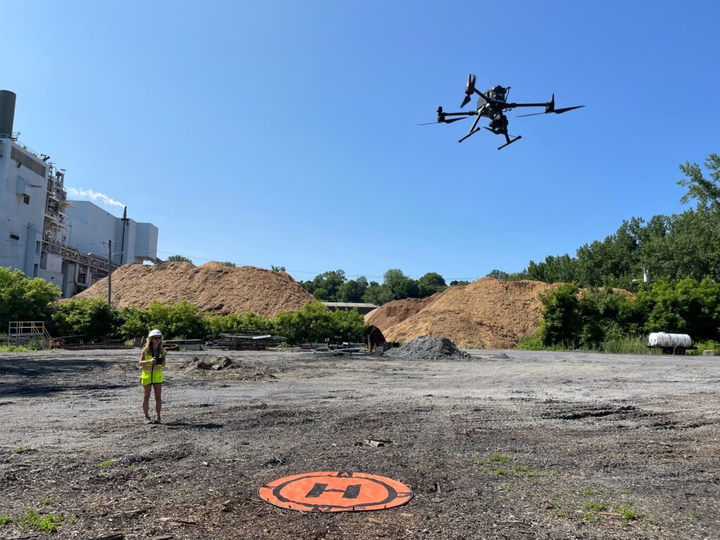
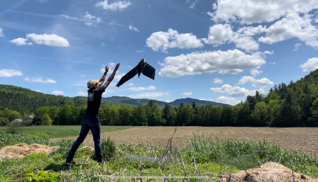
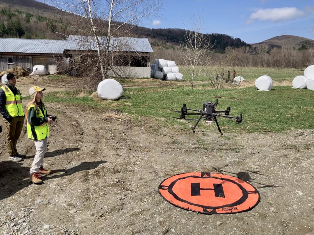
This course is built around a complete, hands-on workflow. Students don’t just learn theory; they practice every step from mission planning to final data analysis. This comprehensive UAS learning experience ensures graduates are ready to apply their skills immediately in a professional setting.
“Our students practice the full workflow—from flight planning and simulated missions to processing and analysis—so they can operate safely and produce reliable maps and 3D models.”
— Adam Zylka, Assistant Director of UAS, UVM Spatial Analysis Laboratory
What’s special about this course compared to other drone programs?
Unlike many programs that focus solely on piloting skills, our course emphasizes the entire workflow—from initial project planning to producing finished, decision-ready geospatial products. The curriculum is deeply practical, teaching students to integrate drone data for real-world applications in GIS and environmental science.
“We designed this course to go well beyond the basics of drone operation. Our students learn how to plan missions, gather high-quality imagery, and process data into valuable information that can directly inform environmental management and policy. This end-to-end approach is what truly sets our program apart for working professionals and aspiring specialists.”
— Adam Zylka, Assistant Director of UAS, UVM Spatial Analysis Laboratory
What software and tech will I use in this course?
Students use a suite of industry-standard technologies throughout the course, including flight planning applications, GIS platforms like ArcGIS Pro, and advanced photogrammetry software such as DroneDeploy. These tools allow learners to plan, execute, and analyze drone missions just as they would in a professional setting. By gaining proficiency in these programs, students can efficiently translate raw data into actionable maps and models.
“We make it a point to train students on the same technologies used by leading professionals in the field. Learning platforms like ArcGIS Pro and DroneDeploy ensures our graduates produce professional-grade outputs from start to finish. Being hands-on with these tools builds both skill and confidence for real-world projects.”
— Kelly Schulze, GIS Specialist and UAS Pilot, UVM Spatial Analysis Laboratory
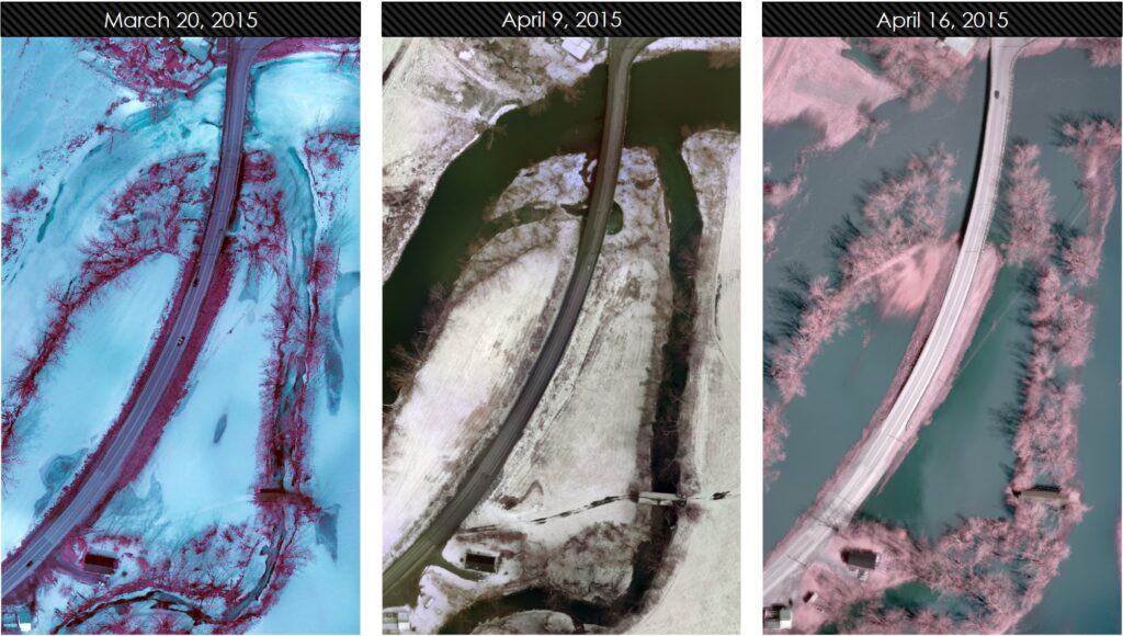
The most critical skill is learning how to transform raw drone imagery into a defensible, decision-ready data product. It’s about moving beyond pretty pictures to create accurate orthomosaic maps and 3D models that can be used for scientific analysis, land management decisions, or environmental monitoring. This is a key focus of our online drone course instructor insights.
“We’re empowering learners to move from raw drone imagery to defensible, decision-ready products—so they can answer environmental questions with confidence and speed.”
— Dr. Paige Brochu, Director, UVM Spatial Analysis Laboratory
What kinds of projects will I work on?
The course includes practical assignments that simulate real-world scenarios, such as planning a drone mission for environmental monitoring or creating a 3D model of a landscape. These projects help students build confidence and apply their skills in meaningful ways.
“Our assignments are designed to mirror the challenges professionals face in the field. Students work on projects that require critical thinking, problem-solving, and the ability to deliver actionable results.”
— Dr. Paige Brochu, Director, UVM Spatial Analysis Laboratory
How are hands-on skills like flight planning taught online?
We use industry-standard simulation software that allows students to plan and execute drone missions in a virtual environment. This drone flight planning Q&A is common, and our answer is that simulation provides a safe and effective way to practice mission-critical skills. Students learn to:
- Define a project area.
- Set parameters like flight altitude, speed, and image overlap.
- Run the simulated flight to ensure complete data coverage.
- Troubleshoot common issues without risking equipment.
This gives students the confidence and competence needed before they operate a physical drone.
“From mapping dry lake beds to quantifying aquatic invasive species, simulation has been an invaluable tool. It allows us to test techniques, refine workflows, and identify challenges in a controlled environment before heading out into the field. This ensures that students are prepared to collect accurate and actionable data in real-world scenarios.”
— Kelly Schulze, GIS Specialist and UAS Pilot, UVM Spatial Analysis Laboratory
What’s the most valuable skill I’ll learn from this course?
The most critical skill is learning how to transform raw drone imagery into a defensible, decision-ready data product. It’s about moving beyond pretty pictures to create accurate orthomosaic maps and 3D models that can be used for scientific analysis, land management decisions, or environmental monitoring. This is a key focus of our online drone course instructor insights.
“We’re empowering learners to move from raw drone imagery to defensible, decision-ready products—so they can answer environmental questions with confidence and speed.”
— Dr. Paige Brochu, Director, UVM Spatial Analysis Laboratory
What jobs can I get after completing this UAS training?
The skills learned in this course are in high demand across multiple sectors. Graduates are prepared for roles in:
- Environmental Consulting: Assessing ecosystem health and monitoring restoration projects.
- Agriculture: Analyzing crop health and optimizing resource use.
- Land Management: Mapping land use change and planning development.
- GIS Analysis: Integrating high-resolution aerial data into broader geospatial projects.
From an instructor perspective on drone mapping, this training provides a significant competitive advantage in the job market.
“When I began my career with senseFly as their first American employee, I saw firsthand how expertise in drone mapping could open doors to incredible opportunities. My role allowed me to support enterprise partners, federal agencies, and even Fortune 500 companies, while also training professionals across diverse industries. These experiences highlight just how valuable these skills are for students looking to make an impact in emerging fields.”
— Adam Zylka, Assistant Director of UAS, UVM Spatial Analysis Laboratory
What’s a common misunderstanding people have about drone mapping?
Many people think the most important part of drone mapping is just flying the drone. In reality, successful projects depend on careful planning before the flight and rigorous data processing after. The quality of your final map or model is determined by how well you execute the entire process.
“High-quality inputs drive high-quality outputs. We emphasize flight parameters, sensor settings, and field protocols that translate into accurate, analysis-ready datasets.”
— Lauren Cresanti, UAS Specialist, UVM Spatial Analysis Laboratory
How does this course relate to the FAA Part 107 certification?
This course focuses on data collection, processing, and analysis, which are the steps that follow a successful flight. While it covers the principles of safe operations, it is not a test prep course for the FAA Part 107 exam. However, the drone operation course details and workflow knowledge you gain are a perfect complement for any certified commercial drone pilot.
Related Reading
- Course Highlight: Intro to UAS and Geospatial Applications
- Overview of UVM’s 100% online GIS Certificate
Looking for More GIS Experience?
UVM’s Professional GIS & Data Communications Certificate Offers Comprehensive GIS Expertise
This 4-course, non-credit GIS & Data Communication Certificate is designed to help you succeed in the growing fields of GIS, geospatial analysis, remote sensing, geospatial computation, and data communication. Turn big data into useful information that helps solve real-world problems!
GIS Certificate Curriculum: Combine four courses together for a customized certificate.
- Introduction to GIS
- Advanced GIS
- Data Visualization and Communication
- Intro to UAS and Geospatial Applications
- Remote Sensing Foundations
- Environmental Modeling
- Geospatial Computation
- Independent Study
UVM’s GIS & Data Communication Certificate is designed to help you succeed in the growing field of GIS and geospatial analysis. No prior GIS experience or background in coding or computer programming is required.
Learn More about UVM’s GIS & Data Communication Certificate.